Seoul National University Develops AI to Detect Satellite Trajectories
Low-Earth Orbit Satellites Like Starlink Surge… Reflected Light Contaminates Astronomical Observations
AI Isolates and Removes Only Trajectory Segments… Successfully Preserves 99.95% of Observation Data
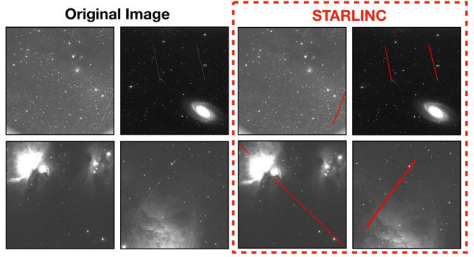
A new artificial intelligence technology called “STARLINC” has been developed to distinguish satellite trails captured in astronomical observation images. In the left image, the original celestial image shows faint satellite trails. In the right image, the red lines indicate the satellite trail positions detected by STARLINC. Photo provided by Shin-Gun Kim, integrated master’s and PhD course student at Seoul National University.
As the number of low Earth orbit (LEO) satellites rapidly increases, including those for SpaceX’s LEO satellite communication service “Starlink,” founded by Elon Musk, satellite trails left in astronomical observation images are becoming an obstacle to observations and astronomical research. Faint satellite trails are difficult to distinguish, and when an entire frame containing a trail is excluded from analysis, valuable celestial observation data are often lost.
According to academia on the 15th, a research team led by Professor Jin-Ho Lee of the Department of Electrical and Computer Engineering at Seoul National University has developed a satellite trail detection technology called “STARLINC.” This AI technology automatically locates satellite trails in astronomical observation images and reduces the loss of celestial observation data. The research results were presented at the “19th European Conference on Computer Vision (ECCV 2026)” held in September this year. The technology was also introduced last month at the Korean Astronomical Society’s “Dark and Quiet Skies (DQS)” special session held at the Gwacheon National Science Museum.
● AI adopting astronomical observation methods LEO satellites reflect sunlight and leave line-shaped traces in astronomical observation images. When these traces overlap with stars, the brightness of the stars can be measured incorrectly, affecting celestial analysis.
Excluding an entire image containing satellite trails from analysis results in the loss of observational information from regions without trails. Although automatic satellite trail detection technologies already exist, they have limitations in distinguishing faint and thin trails in astronomical images with weak signals and substantial noise.
Training AI to distinguish satellite trails is also challenging. Generating “ground truth data” for AI learning requires significant time and effort, as the exact trail positions in real images must be marked precisely at the pixel level.
The research team adopted an existing astronomical observation method that repeatedly photographs the same region of the sky. When the same area is imaged at different times, celestial bodies such as stars and galaxies generally appear in the same positions, while satellite trails appear only in some frames. Using the differences between images, the team generated a “difference map” that suppresses fixed celestial bodies and highlights transient satellite trails.
The team also created AI training data by adding artificial trails to real astronomical images without satellite trails. They implemented a variety of traces by varying length, direction, thickness, and brightness. Because the insertion positions of the artificial trails are known, ground truth training data indicating trail locations can be generated without manual annotation.
A supplementary AI to determine the presence or absence of trails was also developed. By extracting the regions that this auxiliary AI focuses on during its decision process, the team generated a “hint map” indicating likely trail locations, which is then used to help distinguish satellite trails.
Finally, when the original image, the difference map, and the hint map are input into “U-Net,” the AI that segments satellite trail regions in the images, an output is produced that marks the pixels corresponding to satellite trails. These marked images are then compared with the original observation data, and the pixels estimated to be satellite traces are selectively excluded from analysis.
● Preventing loss of celestial observation data The research team used 1,140 images of the Orion molecular cloud region captured by the “7-Dimensional Telescope (7DT)” for the study. The 7DT is a telescope constructed by Seoul National University at the El Sauce Observatory in the Andes Mountains of Chile. Of the images, 720 were used for STARLINC training, 180 for validation, and the remaining 240 for performance evaluation. The evaluation benchmark was ground truth images in which human experts manually marked the satellite trails.
In the performance evaluation, the mean Intersection over Union (mIoU)—an index indicating how much the trail regions predicted by STARLINC overlap with the ground truth regions—was 0.485, higher than existing methods (maximum 0.240). An mIoU value closer to 1 indicates better agreement between the two regions.
The team also compared the preservation ratio, which indicates how much observational data are retained. When all images containing satellite trails were excluded from analysis, only about 79.58% of the total pixels were preserved, whereas with STARLINC, approximately 99.95% were preserved. This significantly reduced the loss of observational information.
Performance was maintained even when STARLINC was applied to other observational datasets without additional training. On images of another sky region taken by 7DT, labeled “NGC,” and on observational images from the “Zwicky Transient Facility (ZTF)” at the Palomar Observatory in the United States, the mIoU values were 0.471 and 0.469, respectively. Both datasets showed higher scores than existing methods.
The system does not detect all satellite trails. The recall, which indicates how many of the actual trail pixels were detected, was 0.545. The research team stated, “Due to the limited availability of public observational data, the evaluation scope is restricted,” and emphasized the need for verification using more diverse observational datasets.
Shin-Gun Kim, an integrated master’s and PhD course student at Seoul National University who participated in the research, said, “Previously, entire contaminated images were often discarded, resulting in the loss of valuable observational data,” adding, “The key significance is that, instead of discarding entire images containing trails, only the pixels corresponding to the trails can be selectively excluded, preserving the remaining observational information.”
ⓒ dongA.com. All rights reserved. Reproduction, redistribution, or use for AI training prohibited.
Popular News