Once, large-scale infrastructure such as HPC (so‑called supercomputers), satellites, and big data platforms was accessible only to a handful of major corporations and government agencies. This was because their use required enormous capital and substantial manpower. However, as advanced technologies such as cloud computing and AI have become widespread, small and medium-sized enterprises and startups can now utilize large-scale infrastructure and are attempting diverse forms of innovation as a result.
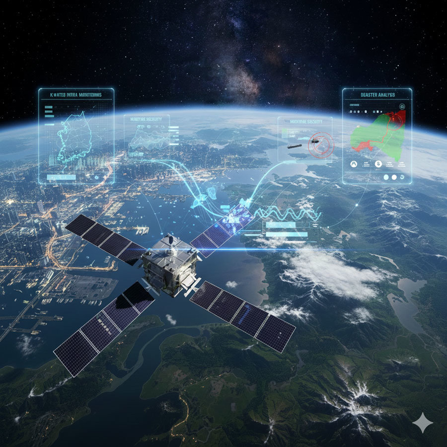
Satellite big data analytics startup StellarVision (CEO Lee Seung-cheol) is a representative example of this shift. The company processes petabyte-scale satellite data entirely in a cloud environment and has achieved results in a wide range of areas, from infrastructure monitoring for Korea Water Resources Corporation to maritime security and disaster analysis. Recently, it won a CES 2026 Innovation Award for an indoor search-and-rescue radar based on SAR technology and signed an MOU with French defense company Thales, gaining recognition in the global market. How has a startup come to operate a business on a “space-scale”?
Source = Image generated with Gemini
An era when startups handle petabyte-scale dataStellarVision chose to leverage a cloud environment instead of building physical infrastructure. This allows it to use only the computing resources it needs and to scale instantly when data processing demand surges. The data StellarVision currently manages, even in compressed form, is measured in petabytes (approximately 1 million times a gigabyte).
As the use of cloud environments has enabled startups to operate large-scale satellite data infrastructure, barriers to entry in the satellite-based Earth observation services market are coming down. Small and medium-sized companies can now handle data on a global scale and develop new services in such an environment.
Using AI for processing and optimizing satellite dataHundreds of satellites image the Earth’s surface every day, generating vast volumes of data. The problem is that most of this data remains stored without being properly analyzed. Raw satellite imagery is difficult to compare as-is due to clouds, atmospheric distortion, and differences in imaging conditions.
StellarVision transforms this raw data into an “analysis-ready” state that can be used immediately by applying cloud removal, atmospheric correction, and normalization. By automating this preprocessing, scientists and analysts are freed from data cleansing tasks and can focus on solving real-world problems.
Once the data becomes analysis-ready, the next step is to identify meaningful changes within billions of pixels. StellarVision operates AI models trained on data from various sources, including satellites, AIS (Automatic Identification System for vessels), and ground sensors.
These models automatically detect objects such as vessels, facilities, farmland, and illegally occupied areas, then precisely align images from different points in time to distinguish change points at the pixel level. The extracted changes are linked into time series to capture patterns and anomalies.
For example, AI first detects how the site of a water resources facility has changed over 3 months, 6 months, and 1 year; what track patterns vessels repeat in a particular sea area; and from what point in time farmland begins to experience stress. Analysts can then concentrate on the core judgment of “where to focus attention” instead of manually examining every image.
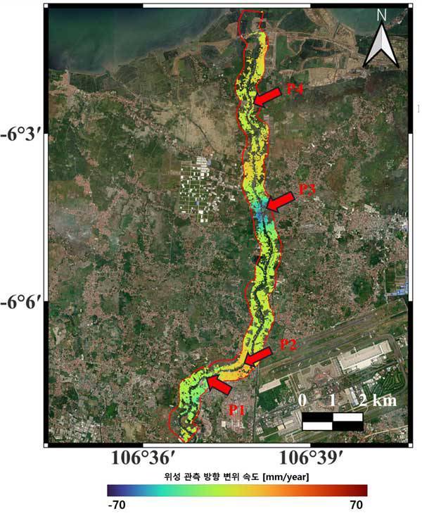
Ground displacement analysis data derived from SAR satellites / Source = StellarVision
‘SAR’ technology that works even under thick clouds and at midnightOne of StellarVision’s core technologies is satellite image analysis based on SAR (Synthetic Aperture Radar). Conventional optical imagery relies on visible light, making it difficult to obtain images when there is heavy cloud cover or at night. In contrast, SAR uses electromagnetic waves, which can penetrate clouds and be utilized even in the middle of the night. It can clearly distinguish water from land, making it useful for identifying flooded areas.
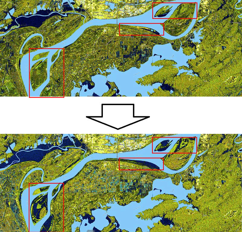
In mid-2024, StellarVision analyzed flooding in Anhui Province, China, using SAR imagery. By comparing images from before and after the flood, the company confirmed that a narrow waterway and dam to the left of the urban area were submerged during the July floods. This was a case where SAR accurately captured information that would have been difficult to discern with optical satellites due to cloud cover.
Using SAR data, StellarVision identified changes in flooding conditions in the Anqing area of Anhui Province from May to July 2024 / Source = Sentinel-1 data: ⓒ ESA
From land management to maritime security… applications across diverse sectorsStellarVision’s technology is being used across multiple domains. In its collaboration with Korea Water Resources Corporation (K-water), it regularly observes changes in managed sites by combining optical and SAR satellite imagery. The AI model compares and analyzes satellite images to detect early signs of illegal occupation or use, unauthorized structures, unplanned road construction, and changes in land use. According to the company, by comparing time-series satellite images at the pixel level, it can identify surface changes on the order of several millimeters to several centimeters. This enables much more efficient management than having people physically patrol wide areas.
Meanwhile, through the National Information Society Agency (NIA)’s “Open Verification Project for Public Sector SaaS Utilization,” StellarVision recently upgraded its solution for K-water from an on-premise model to SaaS (cloud)-based. This has allowed more companies and institutions to access satellite-based data analytics services without significant burden.
In the maritime security field, the technology is used to track “dark vessels” that conceal their positions. On the open sea, some vessels engaged in illegal fishing or smuggling switch off or manipulate their AIS signals. StellarVision combines SAR satellite imagery and AIS data to identify unregistered vessels that appear in imagery without AIS signals, or whose reported positions do not match their actual locations.
In the global food security sector, the company has conducted research using satellite data to monitor crop health and to quantify and detect early indicators of food shortages. Because satellite imagery provides a comprehensive view of large farmland areas, it enables faster and more wide-ranging analysis than on-the-ground surveys.
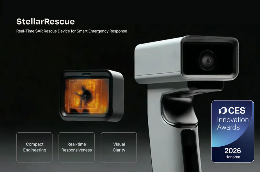
StellarVision’s “StellarRescue,” winner of a CES 2026 Innovation Award / Source = CES
Building global partnerships and winning a CES Innovation AwardStellarVision has secured a data network by partnering with satellite imaging companies such as BlackSky, Umbra, and Capella, and is jointly developing technology with global defense and tech company Thales under an MOU.
The company is currently developing “StellarRescue,” a compact indoor search-and-rescue radar device based on SAR technology, and its conceptual design has been selected for a CES 2026 Innovation Award. It has received a CES 2026 Innovation Award. The goal is to apply the SAR sensor’s ability to penetrate heat and smoke to disaster and emergency response, highlighting its potential as firefighting and rescue equipment that can be used in environments with heavy smoke or debris. By miniaturizing SAR technology, originally used in satellites, StellarVision is examining the technical feasibility of using it as an auxiliary system in environments where thermal imaging cameras or optical equipment are difficult to deploy.
In addition, StellarVision was selected in the first half of this year for “Thales Learning Expedition in SG,” a global defense startup collaboration program run by French defense company Thales. The development of integrated solutions that combine Thales hardware with StellarVision software is anticipated.
“AI is a tool to extend human capabilities”In an interview with reporters, CEO Lee Seung-cheol stressed that he has a clear view of the roles of AI and humans. “AI tirelessly scans millions of satellite images to find minute patterns that the human eye cannot detect,” he said, adding, “But discovering patterns in data and interpreting what they mean in the real world and making decisions based on them are different matters.”
He continued, “Technology does not replace human capabilities; it empowers people to explore broader areas in greater depth,” and explained, “Our solution functions as a ‘satellite-based global-scale CCTV’ that can be applied to local market research, natural disaster damage analysis, infrastructure monitoring, national defense, and many other fields.”
An era is emerging in which large-scale infrastructure is no longer the exclusive domain of major corporations and government agencies. Thanks to cloud and AI technologies, startups can now handle petabyte-scale data, collaborate with global companies, and provide solutions to public institutions. The case of StellarVision demonstrates that this shift is not merely a possibility but a reality.
IT Donga reporter Kim Young-woo (pengo@itdonga.com)
ⓒ dongA.com. All rights reserved. Reproduction, redistribution, or use for AI training prohibited.
Popular News